Research Themes
Monitoring and Understanding Trends in Surface Radiation, Clouds, and Aerosols
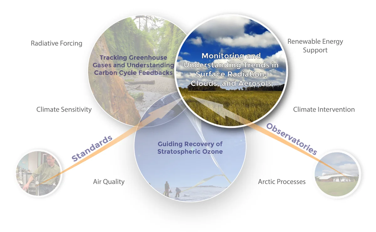
Changes in the radiative energy balance at Earth’s surface and at the top of the atmosphere result from forcing by greenhouse gases, aerosols, and related changes in the global atmospheric circulation. The distribution of clouds is the primary influence on the surface radiation budget and is sensitive to changes in circulation, but the nature of the response of different cloud types in different climatic regions is uncertain. Cloud radiative properties are also sensitive to aerosol particles which are highly variable in space, time, and composition. The role of aerosol particles in radiative forcing is complex and can be either positive or negative and they can influence the climate directly via long term changes in light absorption and scattering. The uncertainty in cloud responses to climate forcing constituents, either through direct interaction with aerosols or through circulation changes, is the primary factor limiting our ability to narrow estimates of the climate sensitivity (the warming resulting from a change in a climate forcing agent).
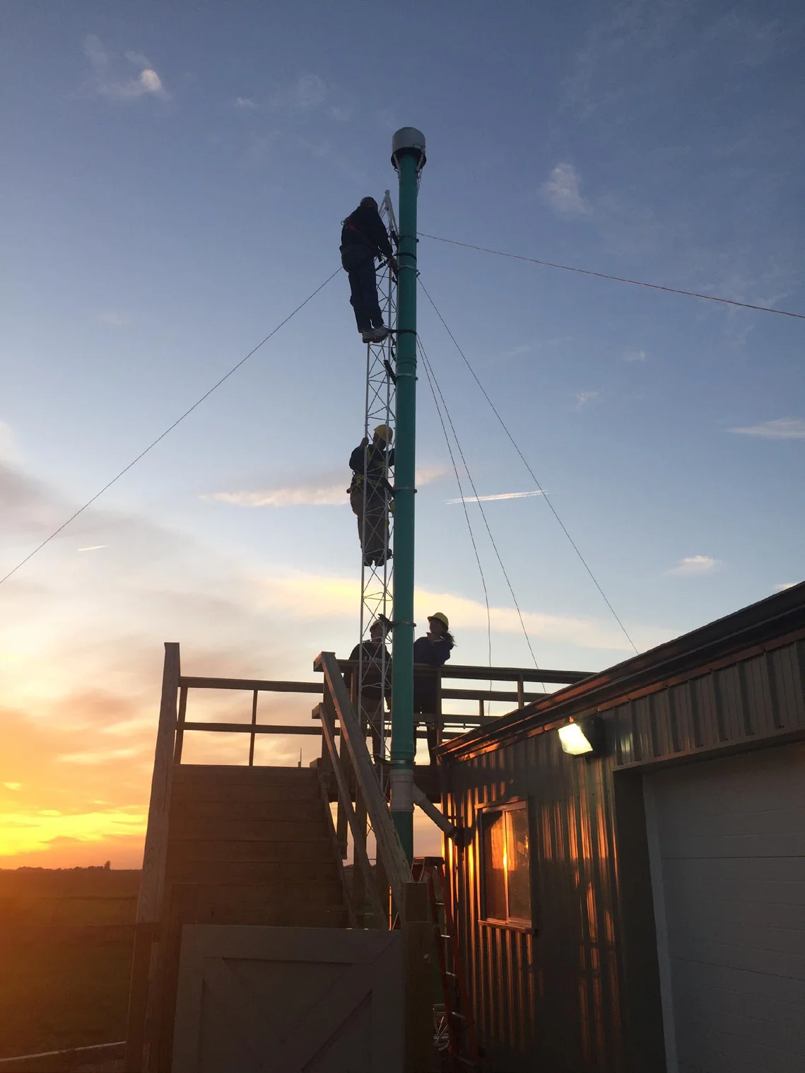
GML observatories host long-term measurements of globally representative, climate-critical radiation variables such as the continuous measurement of the solar energy reaching Mauna Loa Observatory that began in 1958, the longest such record on Earth. Broadband measurements of incoming and outgoing solar and terrestrial radiation are made across the U.S. and at global baseline observatories to quantify the surface radiation balance and to track changes in cloud radiative properties. GML has focused on the direct radiative effects of aerosol particles with measurements of aerosol optical properties that began in the 1970s. In response to the finding that anthropogenic aerosols create a significant perturbation in the earth’s radiative balance on regional scales, GML expanded its aerosol research program to include stations for monitoring aerosol properties in regions where significant aerosol forcing was anticipated.
To support these measurements, GML maintains calibration facilities tied to the world standards and also shares calibration services with collaborators worldwide. GML and its national and international partners have made substantial improvements in the accuracy of both solar and infrared measurements over the past 25 years, allowing detection of small changes in the radiation balance that have dramatic consequences for weather and climate. GML also provides leadership to the international aerosol and surface radiation monitoring communities by providing technical expertise, calibrations, sampling and measurement protocols, and open source data acquisition, processing, visualization and editing software.
How does the surface radiation budget and its components vary in space and time?
Relevance: The surface radiation budget (SRB) represents the energy available at Earth’s surface for driving winds, heating the atmosphere, and evaporating water, and thus plays an appreciable role in driving weather patterns over the short-term and global circulation and climate over the long-term.
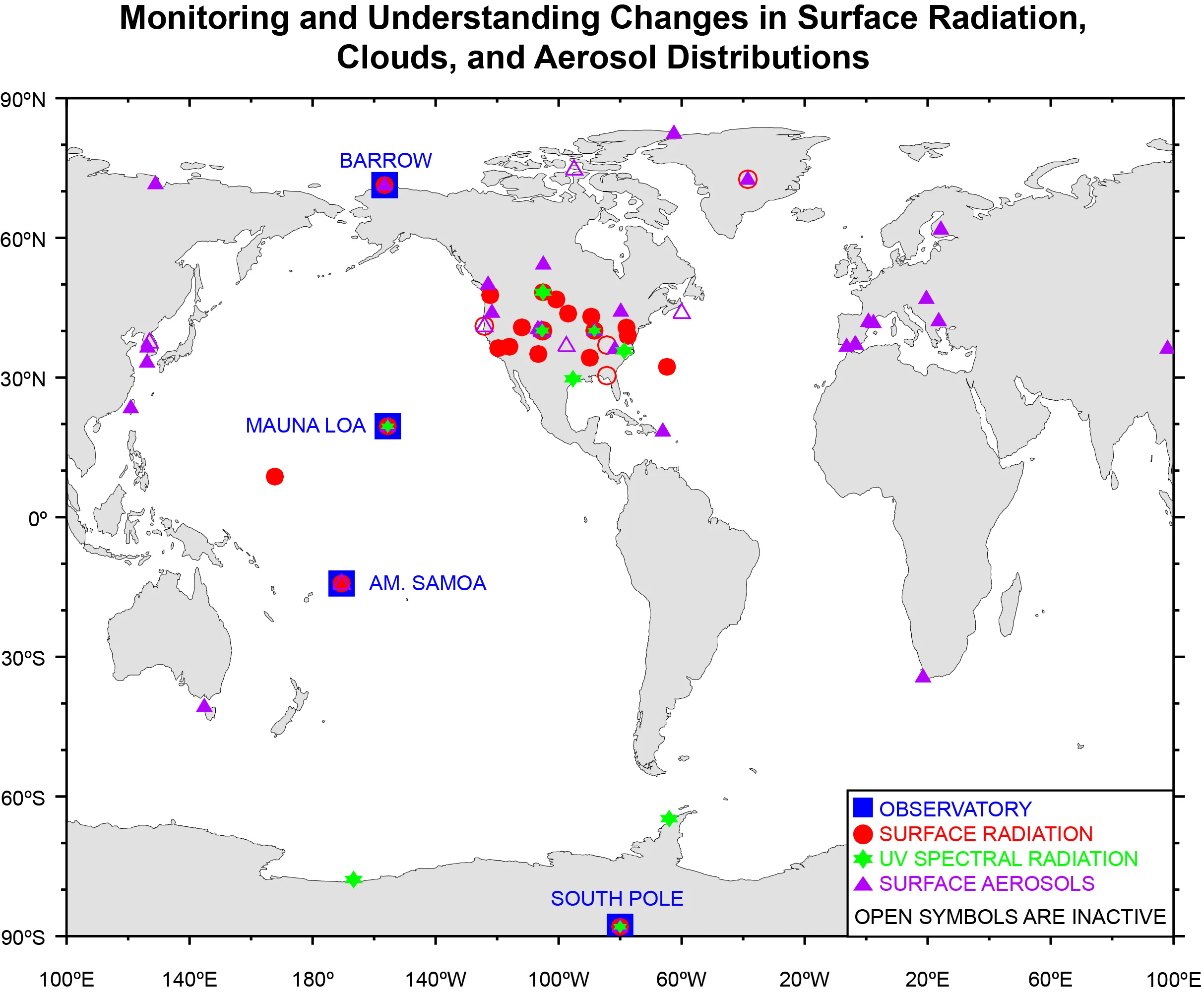
Actions taken: GML makes long-term, continuous, high frequency, climate-quality measurements of the SRB and its components at several locations across the continental U.S. and representative locations around the globe. These observations are a major part of the cooperative, international GCOS Baseline Surface Radiation Network (BSRN, under the WCRP umbrella) that serves as the premier archive of accurate radiation measurements over the globe.
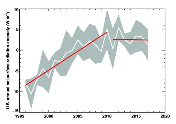
What we’ve discovered: Monitoring of the SRB has revealed decadal changes in ‘Dimming’ and
‘Brightening’, i.e., decreasing and increasing trends in the downwelling shortwave radiation, as the
primary drivers of these trends. The features demonstrate the regionally varying response of the
land-atmosphere energy system to climatically important drivers including anthropogenic GHGs and
aerosols, natural oscillations in the climate systems, and their interactions.
How do anthropogenic forcing and internal variability in the climate system work to redistribute clouds and their radiative properties through feedback mechanisms or aerosol-cloud-radiation interactions?
Relevance: Clouds are the primary modulator of atmospheric and surface heating and cooling and are intricately connected to atmospheric circulation on a range of temporal and spatial scales. The ultimate response of the climate system to anthropogenic aerosol particles and GHGs depends in large part on the trends and variability in clouds and radiation at Earth’s surface. Cloud feedbacks are highly complex and non-linear, differ across climate regimes, and remain the largest uncertainty in projections of future climate states.
Actions taken: Cloud radiative properties – e.g., fractional sky cover, transmission, optical depth in overcast conditions, and the cloud radiative effect – have been monitored and retrieved from surface radiation measurements at GML sites across the U.S. and globally with records exceeding 20 to 40 years. Co-analysis of surface Dimming and Brightening tendencies with trends in cloud properties has provided an understanding of regional characteristics in cloud variability and their impacts on the surface radiation budget. Co-monitored aerosol optical depth has also been used to attribute some variability in the SRB to aerosol direct radiative effects and aerosol-cloud interactions.
What we’ve discovered: Clouds are the primary modulator of the SRB over the U.S. and are responsible for the appreciable trends in downwelling shortwave radiation; the impact is highly significant on decadal scales in comparison to GHG forcing alone. Aerosol direct radiative forcing has a smaller impact on the SRB in the U.S. However, regions that have experienced significant increases in aerosol emissions elsewhere show opposing trends to those in the U.S.
How do the variability and trends of climatically important aerosol optical properties vary as a function of location, time, and atmospheric conditions?
Relevance: Aerosol radiative forcing is very likely opposite in sign of GHG forcing in the global average but may be similar in magnitude. Owing to short atmospheric residence times, aerosol distributions are highly variable. Gaining a better understanding of their weather and climate impacts requires better characterization of their properties and their distributions over space and time.
Actions taken: GML manages a collaborative network of stations that measures surface aerosol scattering and absorption at 27 locations around the globe and column AOD at 13 locations, ranging from clean, remote sites, to sites with regionally representative aerosol types (e.g., anthropogenic emissions or dust).
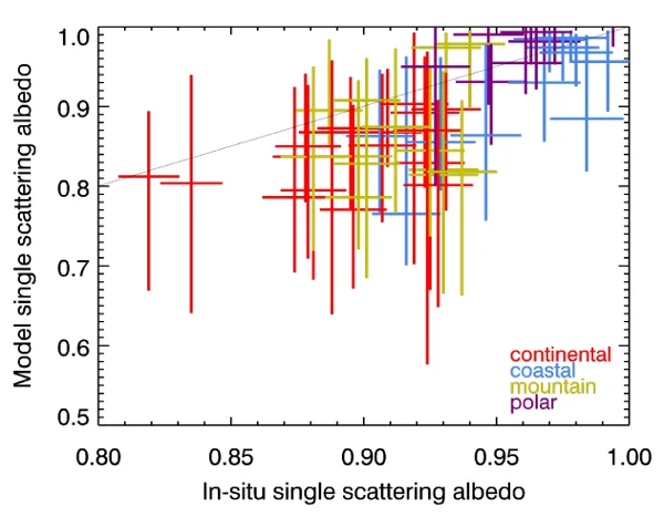
What we’ve discovered: Recent analyses show decreases in tropospheric aerosol at many sites, however long-term measurements in Hawaii and shorter records at Asian sites indicate upward trends. The stratospheric component of the column aerosol extinction in the Northern Hemisphere has been found to track volcanic emissions exceptionally well and may be used to detect stratospheric aerosol changes from natural or human activities, such as attempts at geoengineering. Evaluation of satellite-based aerosol extinction using GML in situ measurements suggest limitations in the satellite data for evaluating such trends, owing to a lack of sensitivity, drift of sensors, and cloud screening errors.
How do changes in atmospheric black carbon and other light absorbing aerosol amounts influence lower atmospheric heating and cloud prevalence?
Relevance: Light absorbing aerosols can cause heating in the atmosphere and at the surface on localto- regional scales, with potentially profound effects on cloud development and lifetimes, atmospheric dynamics, and circulation patterns. The radiative impact of absorbing aerosol particles is dictated by their vertical distribution as well as whether the particles are co-located with clouds, cloud type, the atmospheric dynamical regime and surface albedo.
Actions taken: GML has monitored surface aerosol absorption and black carbon concentrations at many locations around the world, in some places for several decades, and has previously monitored the vertical distribution of absorbing aerosols using instrumented light aircraft.
What we’ve discovered: Absorbing aerosol particles are ubiquitous – they are measured at remote locations such as the South Pole – but the spatial and temporal variability recorded at many long-term monitoring sites cannot be reproduced by climate models. Additionally, our analyses suggest that there is a consistent discrepancy between airborne in situ measurements and remote sensing retrievals of column aerosol absorption, although determining where the errors lie requires further research.
How do changing ozone, aerosol, cloud, and surface properties affect the distribution of ultraviolet radiation at Earth’s surface and what are the implications for issues such as human health and marine ecosystems?
Relevance: Changing stratospheric ozone levels have caused levels of ultraviolet radiation (UVR) reaching Earth’s surface to vary geographically and through time owing to emissions of ozone depleting gases (ODS) and subsequent mitigation efforts (e.g., Montreal Protocol). Changes in UVR at the surface have a range of effects on marine and terrestrial ecosystems as well as human health. Levels of ozone in the atmosphere impact tropospheric chemistry, particularly production of the hydroxyl radical (OH), which is responsible for removal of atmospheric organics. However, factors other than ozone control UVR at the surface – most notably clouds, aerosols, and surface cover – thus measurements of spectral irradiance at the surface coincident with controlling influences are required to understand these impacts.
Actions taken: NOAA, with cooperation from EPA, established the NOAA Environmental Ultraviolet ozone Brewer (NEUBrew) Network of Brewer Mark IV UV spectrometers in 2006 at six U.S. locations that produce absolute spectral UV irradiance. The network of Brewer instruments are currently focused on taking spectral UV irradiance (286-363 nm), instantaneous UV index, and daily erythemal dose. NOAA has also assumed operations of the former Antarctic National Science Foundation (NSF) UV Monitoring Network where multi-channel radiometers are deployed at McMurdo, Palmer, and South Pole stations. These measurements have been used extensively for satellite data product evaluation and a range of process studies.
What we’ve discovered: Variability in cloud cover and surface cover (e.g., the presence of snow) have a stronger correlation to UV surface radiation than ozone. While the UVB dose at the surface depends on changing ozone levels, better understanding of environmental controls on surface UVR is required for assessing these risks.
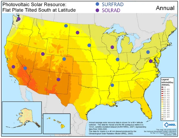
What are the impacts of current and future weather and climate states on solar and wind energy resource availability and efficiency?
Relevance: The availability of wind and solar driven energy is contingent upon weather, which is largely driven by energy at Earth’s surface. Engaging atmospheric sciences to improve short-term weather forecasts specific to alternative energy resources is essential for advancing an efficient carbon-free energy system and concomitantly mitigating climate change.
Actions taken: GML has participated in several projects supported by NOAA and DOE to improve Numerical Weather Prediction (NWP) model representations of land-atmosphere processes critical to effective and efficient exploitation of renewable wind and solar energy resources.
What we’ve discovered: Measurement-model comparisons have led to the identification of model biases resulting from inadequacies in cumulus cloud parameterizations, land surface model errors in energy exchange with the atmosphere, surface albedo characterizations, and aerosol properties. Addressing model errors with observations has resulted in a reduction of the surface solar radiation resource corresponding to a temperature bias reduction of ~70% at the 2 meter level over the U.S. Great Plains.