
HORUS is approved to fly in the national airspace in northeastern Colorado
May 9, 2022
Unmanned aerial systems (UAS) have long been heralded for their unique potential to sample the upper atmosphere at much lower costs and in environments unreachable by most aircraft. However, under normal flight rules, NOAA UAS can only fly up to 1,200 feet above ground level in the national airspace.
NOAA Global Monitoring Laboratory has recently obtained approval from the Federal Aviation Administration (FAA) to fly the High-altitude Operational Returning Unmanned System (HORUS) up to 90,000 ft above mean sea level (MSL) in the national airspace in northeastern Colorado.
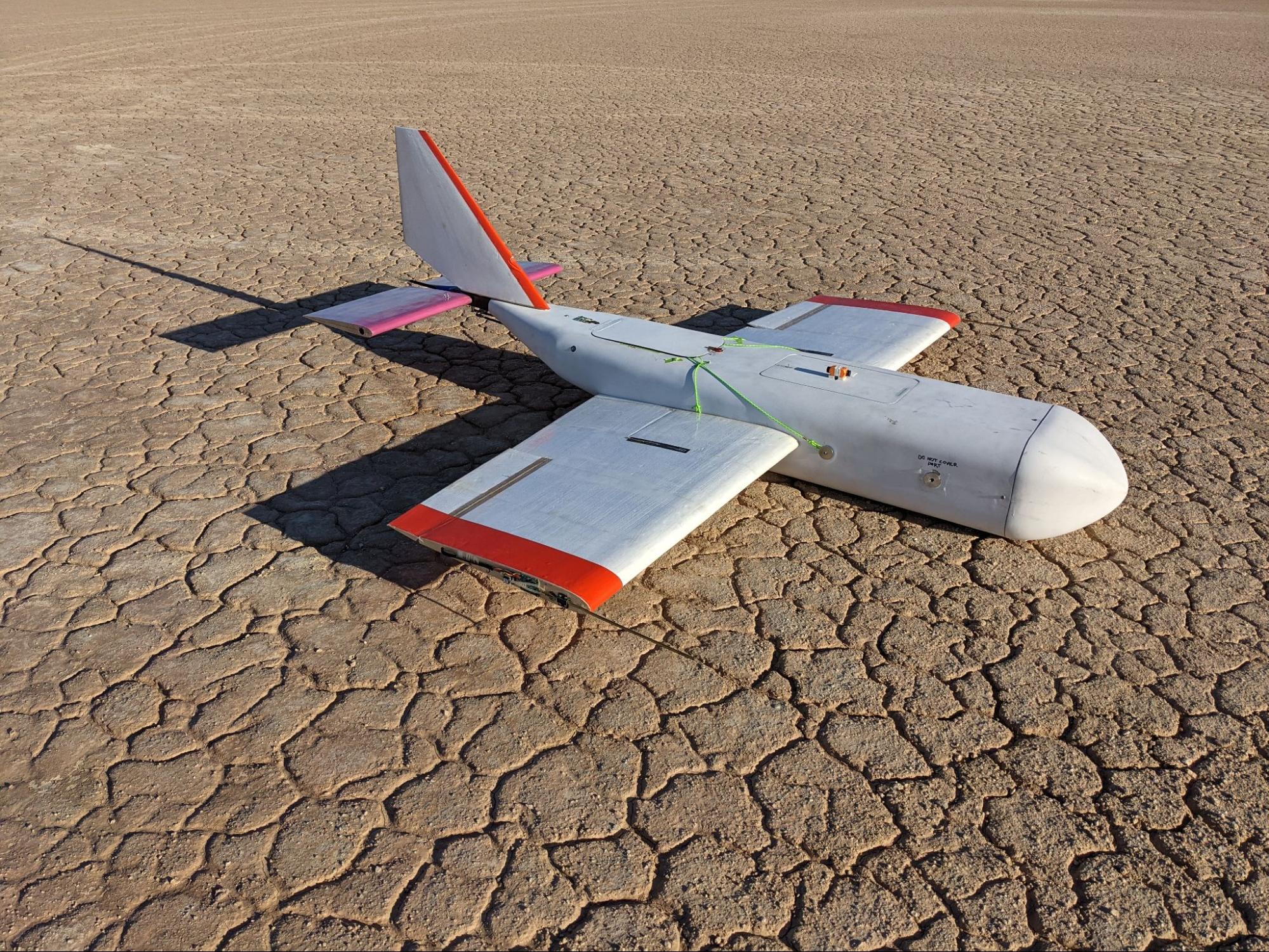
Developed by scientists from NOAA and CIRES, along with collaborators at Arizona State University, Delta Zee Solutions, Spektreworks, and the University of Colorado’s Integrated Remote and In Situ Sensing (IRISS), HORUS is a low-tech, cost-effective balloon-glider system for hosting a small payload of specialized atmospheric instruments to the edge of space, and then guiding it back to its launch location.
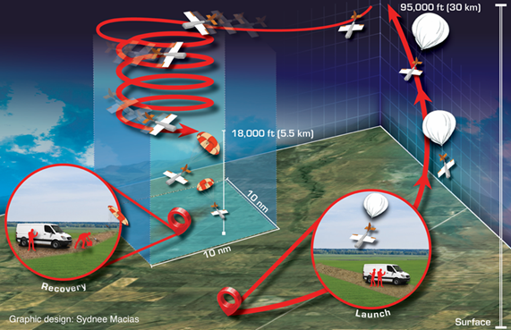
Prior to this FAA approval, the research team led multiple test flights in controlled airspace, demonstrating the full potential of this balloon-glider system to return scientific instruments from 75,000 feet back to the ground. The team is planning its first flight demonstration of the HORUS in FAA-approved national airspace in northeastern Colorado this upcoming September.
“This approval represents a remarkable opportunity for NOAA to revolutionize the way that we currently monitor and observe the atmosphere,” said CIRES scientist Bianca Baier, who leads the effort to develop the HORUS at NOAA Global Monitoring Laboratory. “With this technology, we have the ability to vastly improve our atmospheric measurement and observational potential in regions of the world and layers of the atmosphere that are severely undersampled.”
A groundbreaking step forward in atmospheric observations
Accurate weather forecasting and climate predictions rely on vast amounts of accurate, high-resolution atmospheric observations over large spatial and temporal domains. These observations traditionally come from weather balloons, aircraft, and satellites.
While both aircraft and balloon observations capture a vertical profile of the atmosphere, research manned aircraft rarely reach 75,000 feet MSL or above and are too expensive for frequent sampling. Satellites, which are even more costly, provide continuous monitoring of the atmosphere over large areas, but these measurements are often confounded by clouds, aerosols, and other anomalies that produce biases requiring additional validation from direct measurements.
Despite its relatively low cost, weather balloon instruments might not be easily recovered. Payloads on weather balloons often drift many miles during the ascent and descent due to local wind conditions. If these payloads can be reliably recovered, higher-value instruments with greater measurement accuracy could be flown on balloons, recovered, and re-calibrated for cost recovery of instrumentation.
The HORUS uses a standard weather balloon to carry scientific instrumentation to up to 30 kilometers, or 95,000 feet MSL. When the balloon is released from the payload, the fixed-wing, portable glider with its six-foot wingspan can then be autopiloted back to its initial launch site. With the ability to efficiently recover high-value, high-accuracy instrumentation, the HORUS can significantly reduce the cost incurred from instrumentation that is not typically recovered and can offer a cost-effective way to expand high-altitude air sampling globally.
The History of Development
NOAA’s Global Monitoring Laboratory began the project in May 2019 under the funding and project support provided by NOAA’s Uncrewed Systems Research Transition Office in the Office of Oceanic and Atmospheric Research and the NOAA Uncrewed Systems Operations Center in the Office of Marine and Aviation Operations.
The half-scale version of the HORUS was tested with collaborators in Tempe, Arizona in 2019 which allowed for design checks prior to the development of the full-scale version. In early 2020, the HORUS underwent successful testing under a battery-powered propeller at low altitudes for autopilot tuning and testing of its parachute deployment system.
Following these low-altitude tests, it was also necessary to test the HORUS in its proposed operating environment: that is, at high altitudes where low temperatures and air densities can present issues for control surface functionality and electronics performance.
In coordination with Edge of Space Sciences, and alongside an FAA certificate of authorization for a balloon flight with a slightly heavier payload, the HORUS fuselage – filled with its full scientific payload – was flown on a weather balloon to ~92,000 ft MSL with a parachute-based descent in May 2020.
Then in May 2021, the team successfully tested the HORUS concept of operations (CONOPS) in the restricted airspace at the NASA Armstrong Flight Research Center and Edwards Air Force Base, California, reaching an altitude of 75,000 feet MSL. The success brought the HORUS to a Technology Readiness Level (RL) of 7 out of a possible 9, indicating that the technology has been demonstrated in the same environment required for operational deployments.
The team is currently working to prepare the necessary documentation and the upcoming flight demonstration in northeastern Colorado in September 2022 to bring the technology to operational (RL9) status.