
History of Barrow Atmospheric Baseline Observatory
This is an abridged version of the following sources
- AECOM. National Oceanic and Atmospheric Administration Barrow Atmospheric Baseline Observatory Improvements. March 2019.
- B. Vasel, C. Schultz, R. Schnell, D. Stanitski, and B. Thomas. 2020. New Arctic Research Facility Opens Door to Science Collaborations. Arctic Report Card: 2020 Update. NOAA Arctic Program. DOI: 10.25923/24rn-c757. Accessed at: https://arctic.noaa.gov/Report-Card/Report-Card-2020/ArtMID/7975/ArticleID/908/New-Arctic-Research-Facility-Opens-Door-to-Science-Collaborations
Introduction
In 1973, NOAA established the Barrow Atmospheric Baseline Observatory (ABO) near Utqiaġvik. It is now the longest continuously operating atmospheric observatory in the Arctic with a record of accurate measurements that exceeds all others in this region of the globe.
History of NOAA Global Monitoring Laboratory
Until the 1950s, scientists had obtained limited documentation of atmospheric trace constituents, particularly with regard to “continuous records unaffected by the nearby works of man” (NOAA 1974:v). The increasing necessity for more intensive climate research coincided with the federal government’s establishment of NOAA. NOAA originated in 1970 from a merger of the U.S. Coast and Geodetic Survey (founded 1807), the Weather Bureau (founded 1870), and the U.S. Commission of Fish and Fisheries (founded 1871) (NOAA 2019a). NOAA’s critical mission includes understanding and predicting changes in climate, weather, oceans, and coasts, and applying its atmospheric research to understanding climate change and other environmental issues.
NOAA fulfills an important aspect of this mission through the Global Monitoring Laboratory (GML). This unique laboratory was formed to acquire, evaluate, and make available accurate, long-term records of atmospheric gases, aerosol particles, clouds, and surface radiation in a manner that allows the causes and consequences of change to be understood. The program involves the use of atmospheric baseline laboratories throughout the world to collect atmospheric and solar data.
Read about GML’s mission statement, vision, and research objectives.
NOAA GML Atmospheric Baseline Observatories
NOAA strategically selected locations for observatory sites in Mauna Loa (Hawaii), the South Pole, Barrow, and American Samoa that provide “sample representative latitudes within both hemispheres: polar, mid-latitude, and tropical” (NOAA 1974:2) (Figure 1). Remotely situated far from regional anthropogenic influences, the four “atmospheric baseline observatories” (ABOs) acquire and make available long-term records of atmospheric gases, aerosols, and solar radiation that affect climate, the ozone layer, and baseline air quality (Showstack 2011). In addition to providing samples at representative latitudes with minimal potential interference from human, animal, and plant life, the sites were chosen based on the ability to maintain logistics and personnel at reasonable costs (NOAA 1974:2).
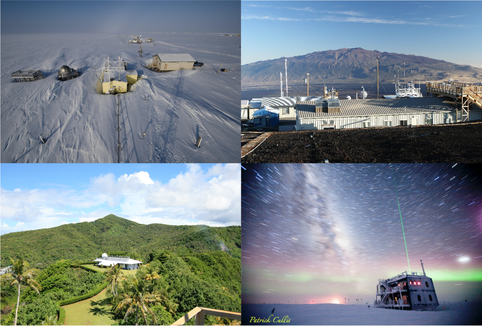
Mauna Loa
Mauna Loa, Hawaii, has long been a site for monitoring and collecting data related to atmospheric change. The site became an observatory in 1955, and scientist Charles David Keeling began measuring carbon dioxide there and in Antarctica in 1958 (NOAA 2017). As a staff member of the Scripps Institution of Oceanography, Keeling obtained critical data from an analyzer placed at the Mauna Loa site that indicated peak levels of carbon dioxide were rising annually, an effect attributed to fossil fuel combustion (Gillis 2010). NOAA determined that Mauna Loa’s limited record was insufficient to reveal global trends, and that “additional new baseline stations should also provide clues as to the cause of the changes in carbon dioxide growth rate” (NOAA 1971:2).
South Pole
The South Pole ABO in Antarctica was initially established in 1957 as part of the International Geophysical Year that promoted scientific interchange during the Cold War era (ESRL 2019b). The early facilities were replaced in the 1970s (NOAA 1974:9).
American Samoa
The American Samoa ABO, established in 1974, is located at Cape Matatula on the northeastern tip of Tutuila Island on a 26.7-acre site. This is the second atmospheric baseline observatory established under NOAA. A three-person staff operates the facility year round (ESRL 2019c). In spring and fall 1972, NOAA conducted preliminary expeditions and land access negotiations in American Samoa for the proposed observatory and completed construction two years later (NOAA 1974:20).
Barrow
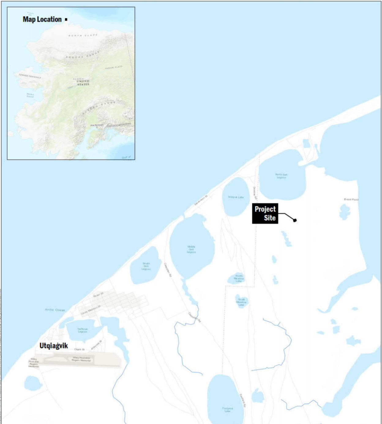
Officially established in 1973, Barrow ABO is NOAA’s northernmost atmospheric baseline observatory and the longest continuously operating atmospheric climate observatory in the Arctic (U.S. Senate 2011:20). It was built while NOAA was launching its global geophysical monitoring system for climate change (NOAA 1971:1). The Barrow ABO is purposely situated upwind of human habitation, in an isolated area which allows for the monitoring of air that has not been impacted by regional air pollution sources. This “clean air sector” receives air from regions where there is no habitation or transport corridor from anywhere between 100 to 5,000 miles upwind of the station (Facility Programming and Consulting 2015:1.4).
Significance of the Barrow ABO
Focused on global climate change research, the Barrow ABO measurements include the longest continuous records of atmospheric carbon dioxide and fluorocarbon trace gas concentrations, aerosols, surface and total column ozone, and solar radiation anywhere in the Arctic. Climate measurements at the Barrow ABO are particularly critical, because global climate change is being experienced more rapidly in the Arctic than at lower latitudes (Facility Programming and Consulting 2015). NOAA has maintained consistent sampling methods at the Barrow ABO since it opened in 1973 to maintain long term consistency and avoid introducing biases into the data (Schultz 2019).
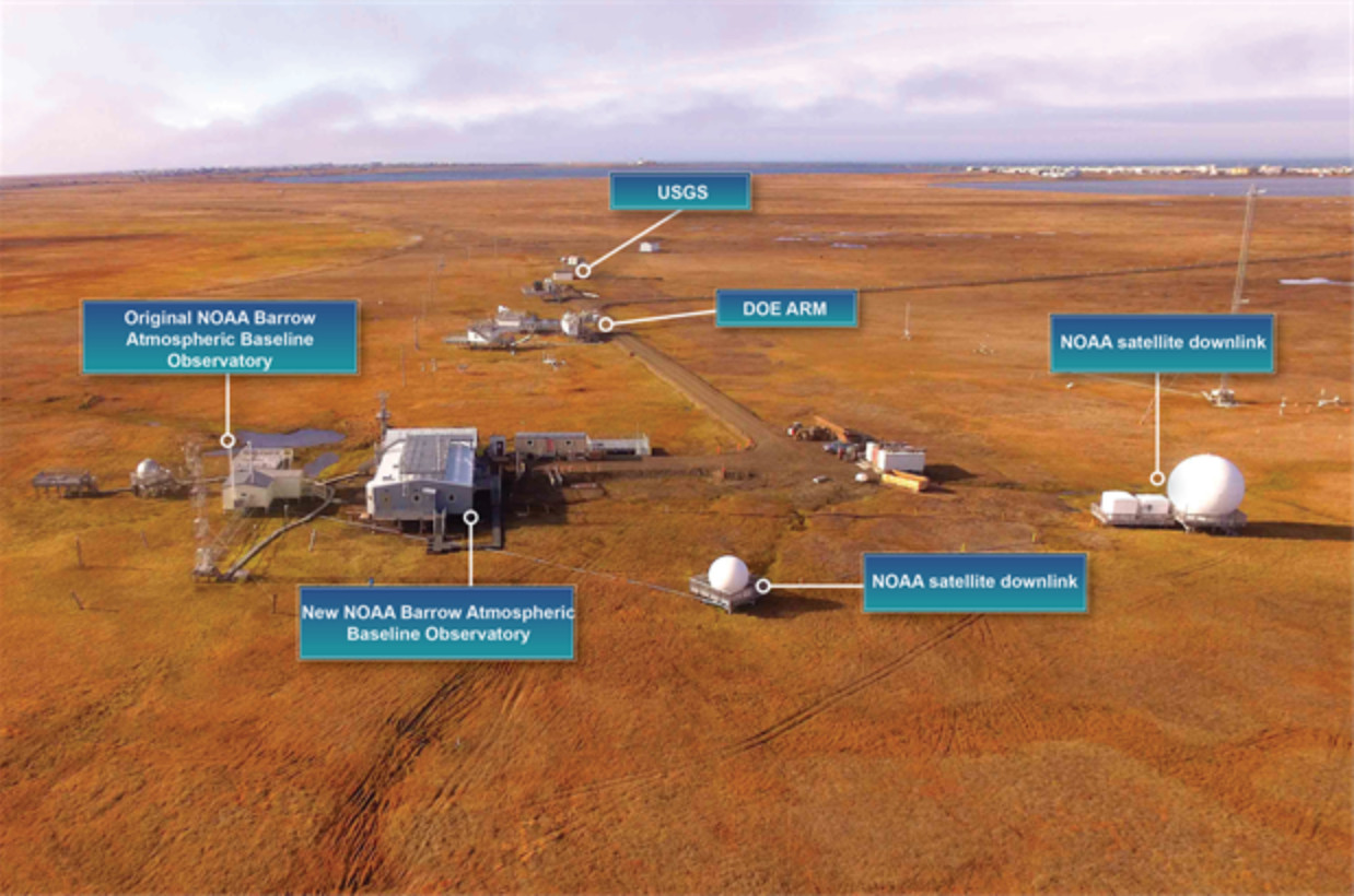
In addition to housing NOAA’s atmospheric research, the Barrow ABO also hosts over 20 cooperative projects from universities and federal agencies, such as NOAA’s National Environmental Satellite, Data, and Information Service (NESDIS), the Department of Homeland Security, the Department of Energy (DOE), the Environmental Protection Agency (EPA), U.S. Geological Survey (USGS), and universities, including three projects from the University of Alaska. Publications using data from the Barrow ABO have appeared in scientific journals such as Atmospheric Chemistry and Physics, Global Biochemical Cycles, Atmospheric Environment, and Journal of Geophysical Research-Atmospheres (ESRL 2019d). Barrow ABO measurements are anticipated to continue for at least the next 100 years and are core elements of NOAA’s responsibilities for monitoring the state of the current global atmosphere and changes over time.
Barrow ABO Facilities and Features
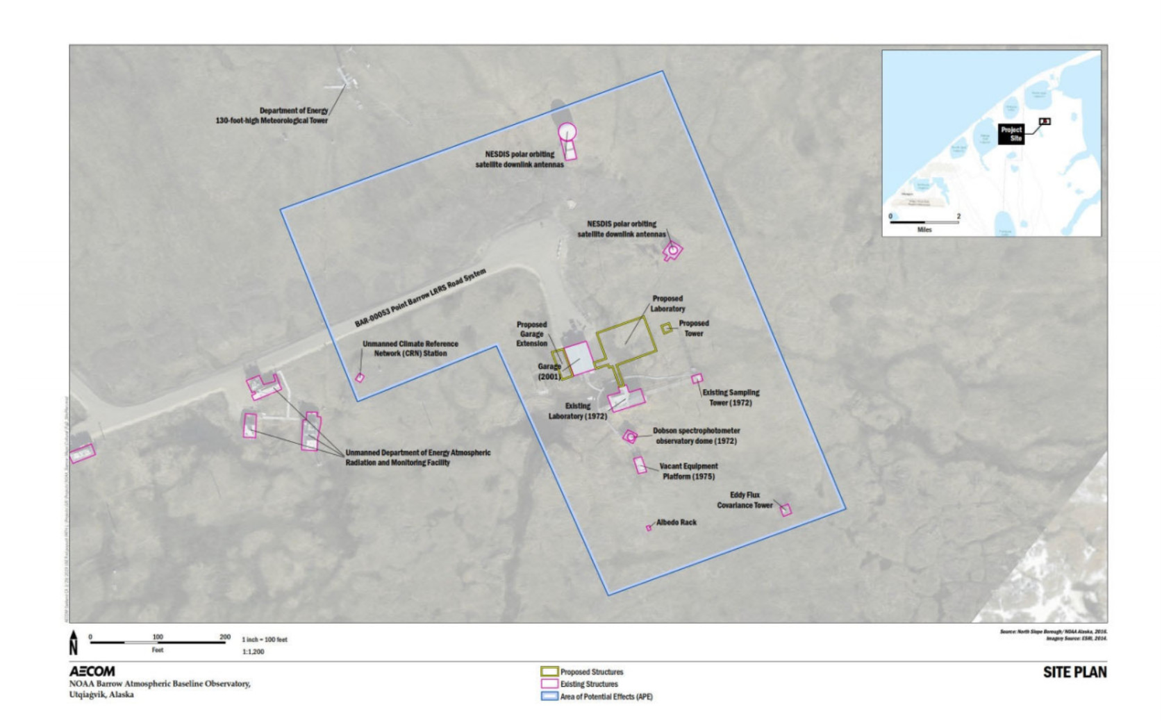
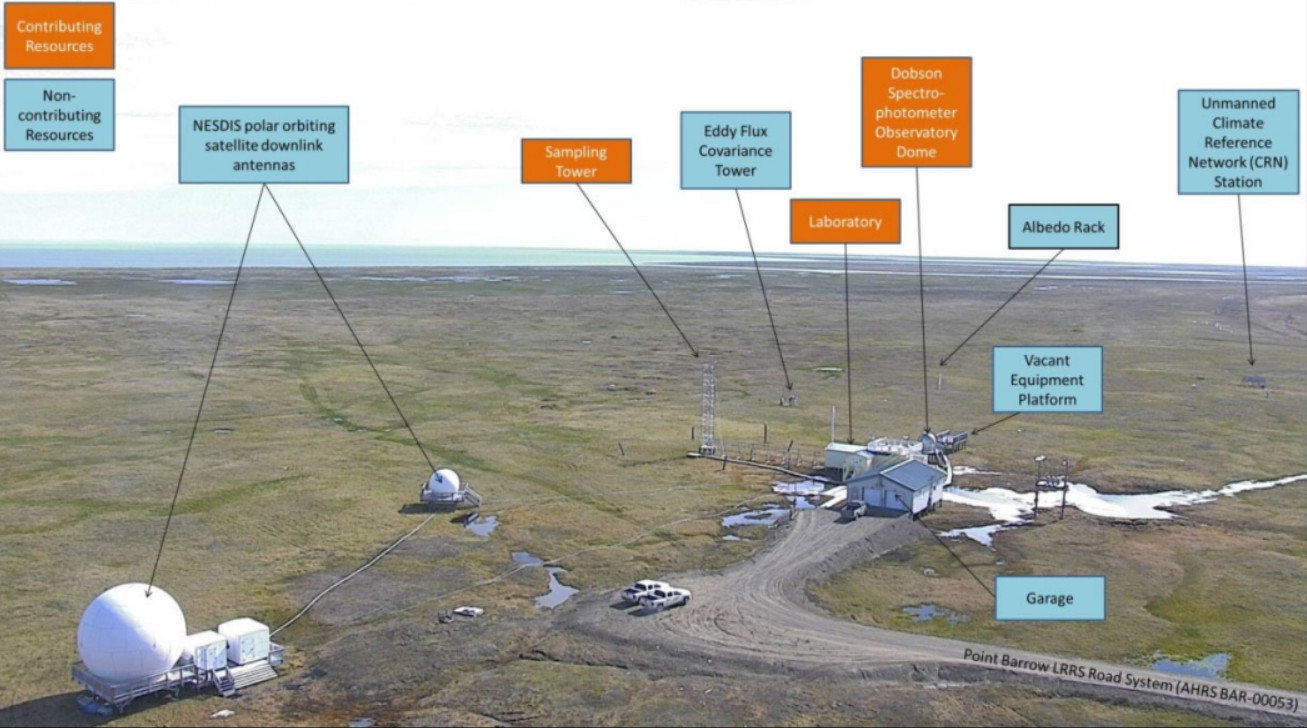
The NOAA Barrow ABO Historic District, established by the Alaska State Historic Preservation Office in 2019, is located on a 115-acre parcel near Utqiaġvik and contains three contributing resources: the laboratory, sampling tower, and Dobson Dome, all built in 1971-1972 (Figures 2-4). A large garage, built in 2001 is non-contributing. In addition to observatory-related buildings and structures, the district contains additional non-contributing structures and equipment that were built outside of the period of significance, which is 1973 – 1982, and are unrelated to the observatory’s primary operations and historic significance.
The sampling tower and Dobson Dome each operate in conjunction with the laboratory to conduct data collection and research at the observatory. In order to sample greenhouse gases, halocarbons, and other atmospheric gases, air is pumped from several different heights on the sampling tower through tubing into the laboratory, where it is analyzed by in situ instrumentation, or used to fill sample flasks that are sent back to NOAA’s Boulder, Colorado, facility for analysis. In addition, meteorology data are sampled at two different heights on the tower using four types of instruments; meteorology data are compiled by a data logger at the tower base and transmitted back to the laboratory via network connection (Schultz 2019).
From the Dobson Dome, technicians manually operate the Dobson spectrophotometer to make total column ozone measurements. Electronic files containing the observations are generated on the Dobson computer, transmitted to the laboratory building via network connection, and sent to NOAA in Boulder for analysis (Schultz 2019).
Laboratory Building
The laboratory is the center of operations and a contributing resource to the Barrow ABO Historic District. In 1971, the year after NOAA was formed, the Navy partnered with its Polar Program Office to build the Barrow ABO laboratory for NOAA’s scientific use. In 1972, the Navy constructed the laboratory building, the site’s access road, and associated power transmission structures (Vasel 2019). According to NOAA’s summary report for 1972, “the first pilings for the laboratory were set in late spring of 1972 . . . In early fall 1972, a three-wire pole line and a road bed was completed from the DEW-line site, a nearby Air Force facility. Except for heaters, electrical wiring, floor, and ceiling tile, the laboratory was complete by the end of 1972. In addition, pilings for the Dobson and tower platforms had been placed (NOAA 1974:20).
Electrical power is provided by overhead transmission lines from Barrow Utilities and Electric Cooperative, Inc., with the main feed into the garage since 1995 and a direct feed into the laboratory. The Barrow ABO previously obtained power through a transformer at the nearby Naval Arctic Research Laboratory. Critical instruments such as the gas chromatograph used battery power for backup.
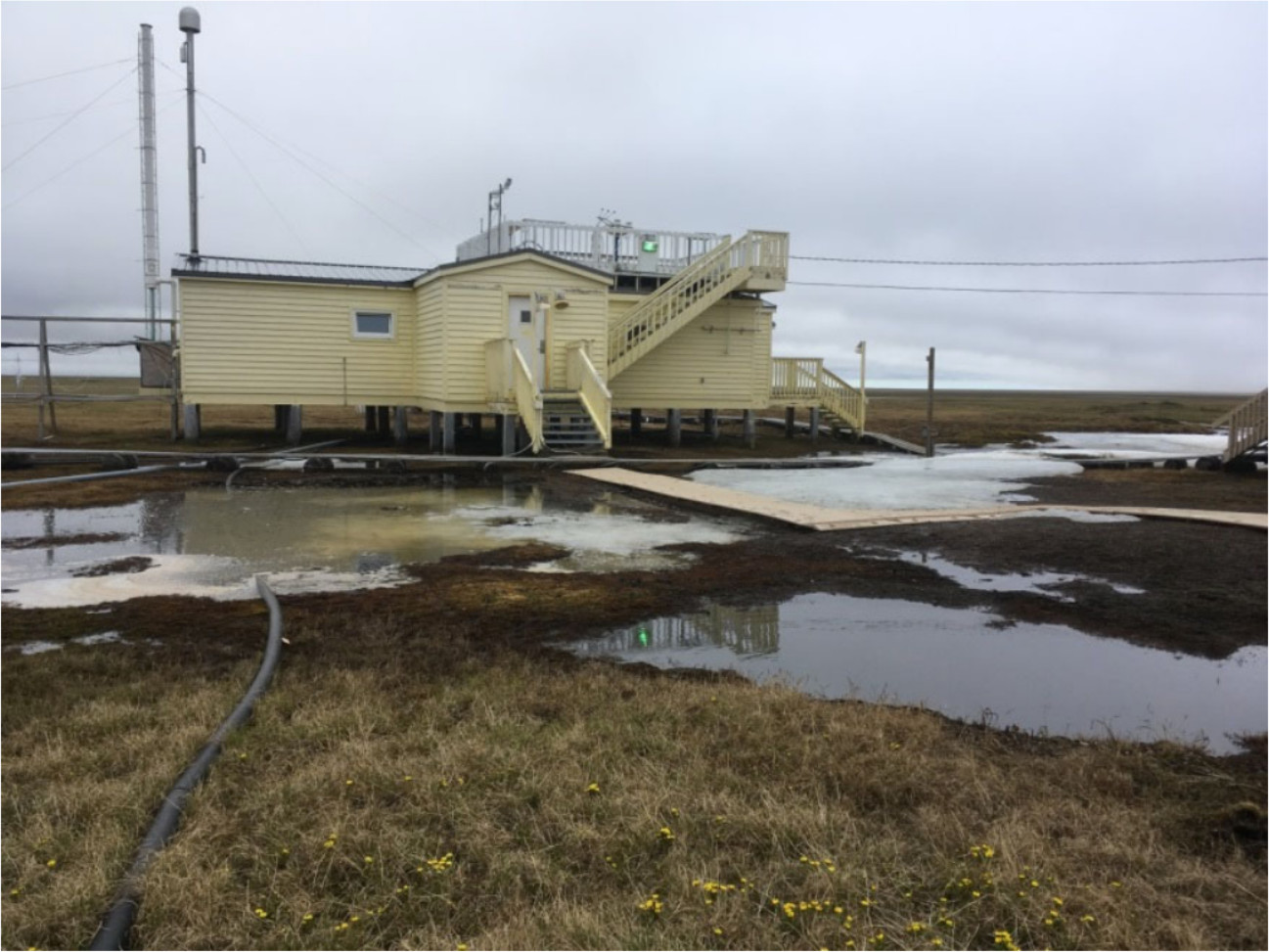
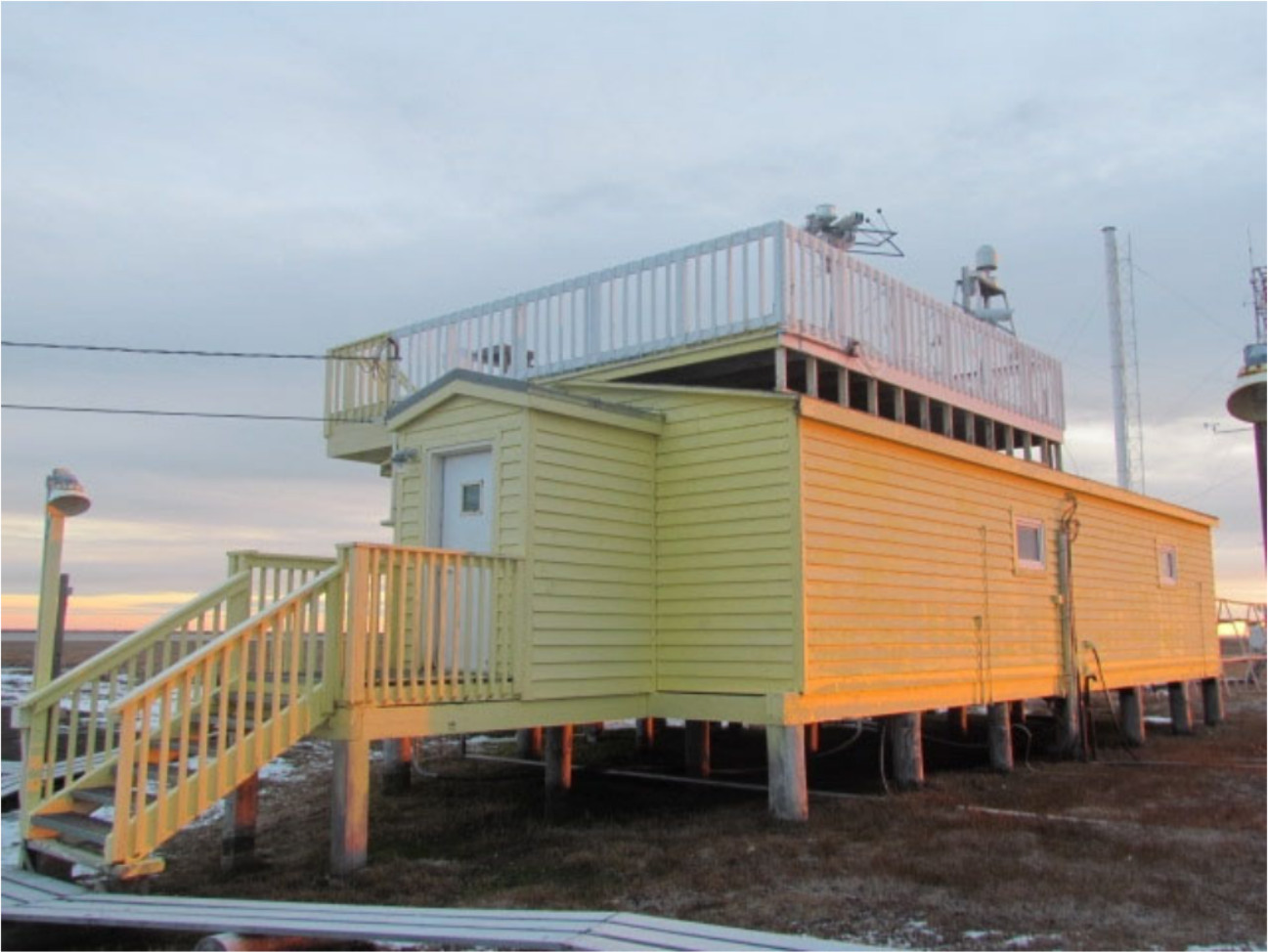
The one-story, 960-sq.-ft. wood-framed laboratory has housed ongoing climate science research since 1973, when NOAA officially opened the observatory. The building has a rectangular shape with projecting arctic entries at the west and north elevations (Figures 5 and 6). The main section of the gable roof is covered with asphalt roll roofing, while the arctic entries are both roofed with standing seam metal roofs. A wooden observation platform with 36-in.-high railing was constructed atop the roof. An exterior wooden staircase provides access to the observation platform. The siding is original wood lap. Like the observatory’s other structures, the laboratory building is founded on timber pilings that appear to incorporate a freeze back-style placement method (Facility Programming and Consulting 2015:2.3-2.8). This enables pedestrian access during times of deep snow accumulation. Wooden staircases lead to each of the two arctic entries, which are configured as two-door arctic vestibule systems consisting of a hollow metal exterior door with small inset pane and an interior door used to prevent cold winds from directly entering the facility. The two arctic entries are similar in construction; however, the one along the north elevation has an additional side-door. A wooden staircase connects this side door to the observation deck on the roof. All windows are vinyl tilt/turn types installed in 24 x 26 in. openings to provide both awning and casement operations. At the west and north elevations, windows flank the arctic entry. The south elevation has two windows (Figure 6) and the east elevation contains one centered window (Figure 7) (Facility Programming and Consulting 2015:2.6-2.7).
The laboratory contains equipment for facility research and also serves as the observatory’s office. There are two interior doors – one to a small storage room and the other to the access space for the air handler. The ceiling is covered in acoustic tile. The building lacks a fire protection and suppression system, sanitation/toilet facilities, running water, break area, and separate office space (Facility Programming and Consulting 2015:2.10).
Alterations
Alterations to the laboratory building since its original construction include the installation of larger arctic entries with stairways and landings (1996-1997), two new door openings at the north entrance (1996-1997), new observation deck rails and stairs, vinyl windows, upgraded interior carpet, walls, and ceiling (1984-1985), and a redesigned instrumentation layout (1984) (Vasel 2019). Historic photographs from 1973 and 1981 also indicate that two small symmetrically-spaced windows on the east elevation were infilled and replaced with a single central window, and the building’s original exterior light fixtures were replaced.
Sampling Tower
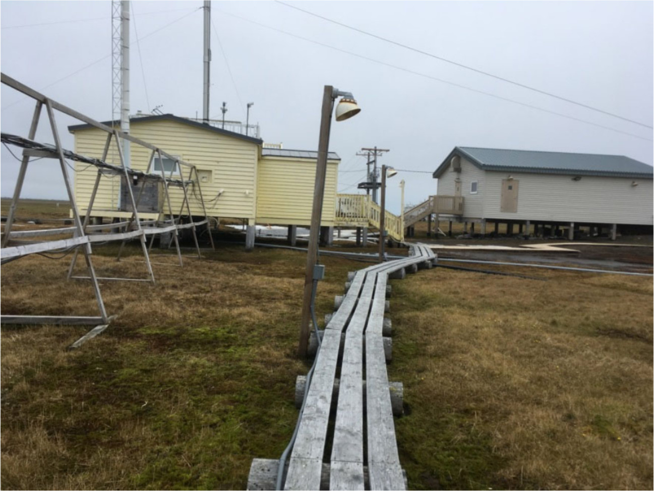
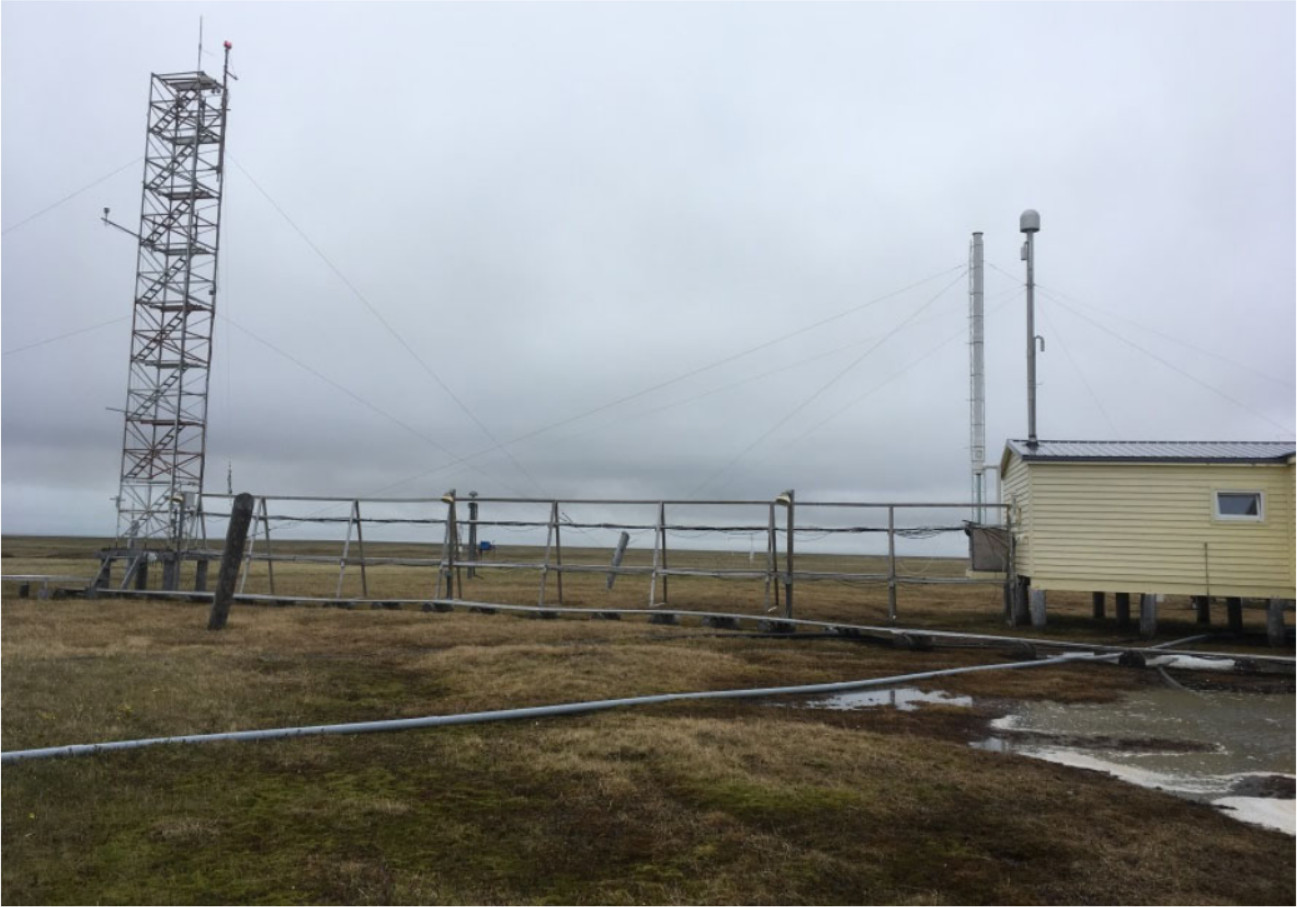
The site’s original 60-ft.-tall walk-up sampling tower is located immediately east of the laboratory and is a contributing resource to the Barrow ABO Historic District (Figure 8). The aluminum tower with full-height stairway enables researchers to obtain air samples, further removed from the influences of vegetation on the ground below. The tower structure consists of combined scaffolding sections that enable researchers to climb the tower and conduct work from the interior. The tower is stabilized by a series of guy wires. The manufacturer is UpRight Scaffold, which has been in business since 1946 (Vasel 2019; UR Scaffold 2019). NOAA uses this tower type at two other sites and previously used the tower type at a third site for approximately 20 years until sea salt corrosion rendered it unsafe. As part of the project, NOAA plans to replace the existing sampling tower with the same product (Vasel 2019). An approximately 100-ft. section of the site’s wooden walkway begins at the laboratory’s north-side arctic entry and extends to the foot of the tower. A metal structure supporting power and data cables extends from the laboratory to the tower. In general, GML’s air sampling methodology has not significantly changed over the years, beyond careful upgrades to instrumentation, electronics, and the integration of computers to increase accuracy, precision, and efficiency (Schultz 2019).
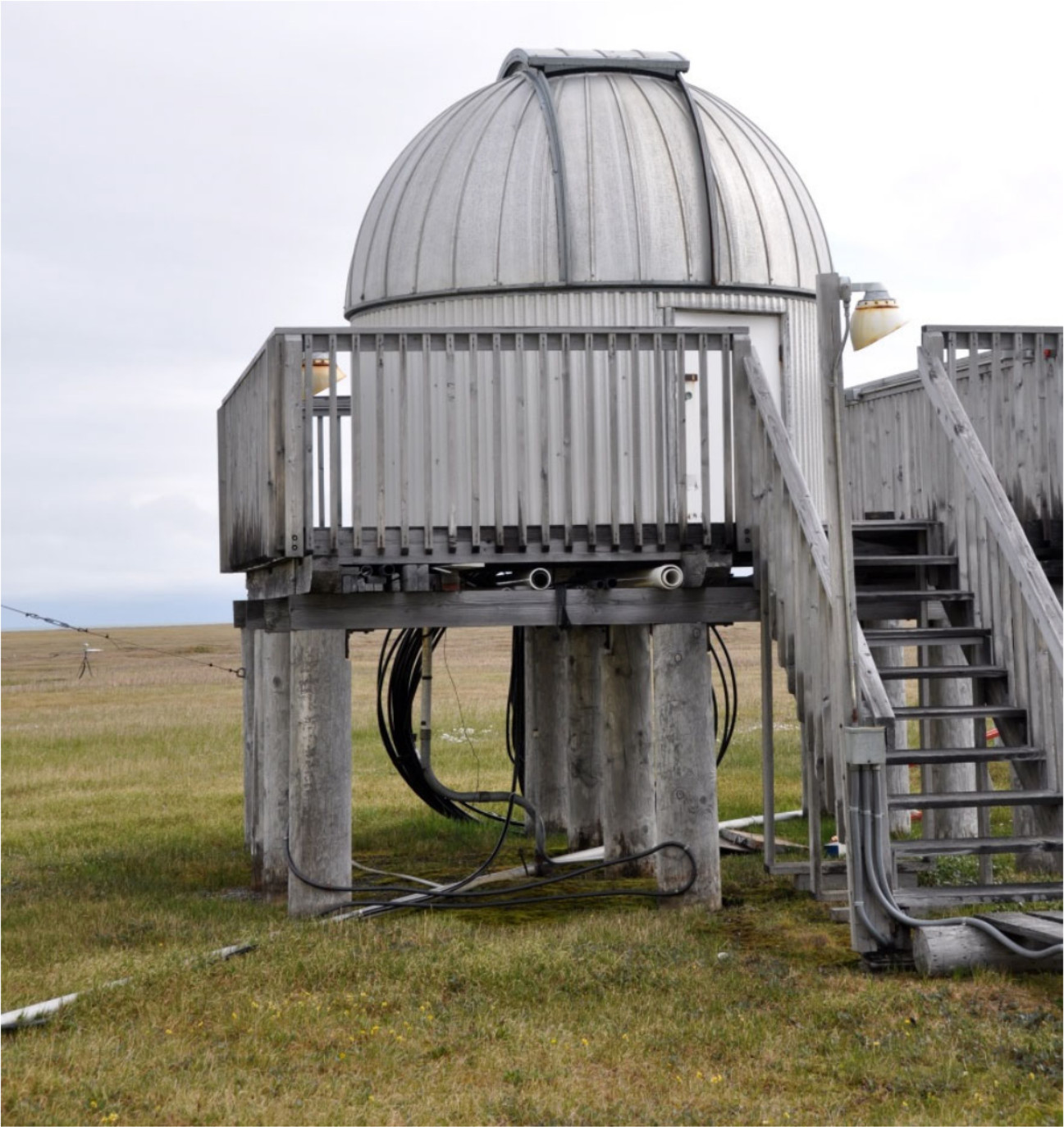
Dobson Dome
The Dobson Dome, located immediately south of the laboratory, is an aluminized steel structure with a dome roof that houses a Dobson spectrophotometer (Figure 9). The dome was produced by Ash Manufacturing Company, Inc. in Plainfield Illinois, one of the largest dome manufacturers, and is a standard astronomy and weather service dome. Ash describes the dome as a “hemisphere of aluminized steel, formed by the joining of a number of interlocking and self-supporting segments into a weathertight dome roof” (Ash n.d). At the Barrow ABO, the dome’s raised wooden equipment platform is supported by approximately 12 timber piles. The platform has wooden guardrails and is accessed by a 10-step, northwest-facing wooden staircase. A short metal door provides access to the dome’s interior. A wooden walkway extends from the laboratory to the dome. Based on a comparison of historic and recent photographs, the Dobson Dome has no evident alterations except for installation/upgrades to the staircase and platform guardrails. Furthermore, NOAA has implemented no special alterations for the Dobson Dome at the Barrow ABO site (Vasel 2019).
G.M.B. Dobson built the first Dobson spectrophotometer in the 1920s to “investigate atmospheric circulation by measuring changes in atmospheric ozone” (NOAA 2008). Barrow’s Dobson instrument record began in 1973, when the facility officially opened (Evans et al. 2017:12054). The dome’s roof shutter allows the Dobson instrument inside to detect the sun. The shutter retracts 1 to 3 times daily depending on the weather and cloud cover. On a sunny day, the retraction occurs around 10 am, noon, and 2 pm for 20 to 30 minutes at a time. Using the Dobson spectrophotometer, scientists compare two different wavelengths of light, one that reacts with ozone in the atmosphere and one that does not, to calculate the total amount of ozone in the air-mass above the site (Vasel 2019). The instrument was out of operation between 1983 and 1986 due to lack of funding (Evans et al. 2017:12067). In an article published in The Best American Science and Nature Writing 2017, Tom Kizzia described the dome’s appearance, function, and legacy: At the NOAA facility two young technicians led me to a rooftop platform looking across the tundra . . . The technicians pointed out the Dobson spectrophotometer: a small silver dome standing alone, like a miniature planetarium, and tracking changes in the earth’s ozone layer. Forty years ago, when scientists first installed a dome there, the world was awakening to concerns about ozone-erasing chlorofluorocarbons. The chemicals began to be phased out in 1989, and now, decades later, the stratosphere shows signs of stabilizing. The dome on the tundra seemed a small shrine to hope (Kizzia 2017:90).
NOAA currently uses the dome for its Dobson instruments at Barrow ABO, as well as at over two dozen sites around the world, including three at the Boulder, Colorado facility (Vasel 2019). Total column ozone is measured from about 80 sites around the world, including Barrow.
Read more about GML’s Dobson program
Barrow Facility Improvements Completed 2020
47 years after it was commissioned, the science has outgrown the observatory’s original modest accommodations. The new, state-of-the-art research facility constructed on the NOAA site is poised to support the observatory's vital role furthering Arctic science for decades to come. In 2020, after years of preparation and planning, a new 273 square meter (2940 sq ft) building to house the Barrow ABO is opening its doors to interdisciplinary scientific collaboration. The facility includes a new roof deck, a 30 m (98 ft) instrument tower, a campaign science platform sized to hold two 6 m (20 ft) metal shipping containers, a dedicated computer server room, a high-speed fiber connection to the contiguous U.S., a plumbed bathroom and kitchenette, a garage remodel and expansion, and a permafrost temperature monitoring facility (Figure 10.)
NOAA awarded the design/build contract to an Alaska Native Corporation, UIC Nappairit, LLC, a subsidiary of Ukpeaġvik Iñupiat Corporation (UIC). UIC designed the facility to qualify as a Leadership in Energy and Environmental Design (LEED)-certified building with the U.S. Green Building Council and has already achieved that mark. The building may still qualify for a higher level of LEED certification as the project is completed, continuing NOAA's commitment to environmental stewardship in the Arctic.
The Barrow ABO revitalization project also brings a fiber connection to the observatory; this new high-speed connection will enable faster data sharing and better communication with school and media outlets in exciting ways. The ability to stream live video and move large data sets out of the Arctic—from ship-borne missions, aircraft campaigns, buoys, and satellites—creates the potential to access the remote Arctic in novel ways.
Final Disposition of Contributing Resources
The original laboratory building will initially remain on site to provide short-term storage or other auxiliary functions, but will be removed in Fall 2021. The existing tower would be dismantled and removed from the site once the new tower is fully operational in Summer 2021. Instrumentation and air inlets from the existing tower will be relocated to the new tower. The Dobson spectrophotometer, housed in the Dobson Dome, will be moved into a room at the new laboratory with windows that open to allow continued measurements. Relocation to the new laboratory will enhance temperature stability for the instrument, thereby promoting more accurate measurements and more robust science (Vasel 2019).
Conclusion
Today, the Barrow ABO supports more than 200 measurements enabling critical research on changes in atmospheric composition and the Arctic region, including greenhouse gases, ozone-depleting chemicals such as chlorofluorocarbons, air pollution events from Eurasia known as Arctic Haze, stratospheric ozone depletion, and advancing snowmelt dates and lengthening of summers along Alaska's North Slope. Data acquired at the Barrow ABO are available online. Arctic modeling and satellite observations will benefit from the infrastructure and science available at the Barrow ABO that allows in situ observations as part of a larger, integrated system. Increasing the number of diverse measurements at the new Barrow ABO facility will improve knowledge of the complex Arctic environment, including the hydrology, glaciology, oceanography, terrestrial, and biological systems, as well as mechanisms related to the entire Arctic system.
References
- Ash. n.d “Ash-Dome” [product brochure]. http://www.ashdome.com/images/Pdfs_drawing/AshDome_cat.pdf (accessed April 3, 2019).
Earth Science Research Laboratory (ESRL)
- 2013 “NOAA’s Barrow, Alaska, Observatory Marks 40 Years of Continuously Monitoring Carbon Pollution in the Arctic.” Global Monitoring Division. July 24. https://www.esrl.noaa.gov/gmd/news/brw40th.html (accessed March 14, 2019).
- 2019a Global Monitoring Division. https://www.esrl.noaa.gov/gmd/about/aboutgmd.html (accessed March 14, 2019).
- 2019b South Pole Observatory. Global Monitoring Division. https://www.esrl.noaa.gov/gmd/obop/spo/ (accessed March 14, 2019).
- 2019c American Samoa Observatory. Global Monitoring Division. https://www.esrl.noaa.gov/gmd/obop/smo/ (accessed March 14, 2019).
- 2019d Publications [Barrow]. Global Monitoring Division. https://www.esrl.noaa.gov/gmd/publications/search2.php?abstract=Barrow (accessed March 14, 2019).
- Evans, Robert D., Irina Petropavlovskikh, Glenn McClure-Begley, Glenn McConville, and Dorothy Quincy). 2017. “Technical Note: The US Dobson Station Network Data Record Prior to 2015, Reevaluation of NDACC and WOUDC Archived Records with WinDobson Processing Software.” Cooperative Institute for Research in Environmental Sciences Faculty Contributions 77. University of Colorado, Boulder. https://scholar.colorado.edu/cires_facpapers/77 (accessed March 21, 2019).
- Facility Programming and Consulting. 2015. Facility Condition Assessment and Project Justification for NOAA OAR Atmospheric Baseline Observatory (Barrow, Alaska). Final - April.
- Gillis, Justin. 2010. “A Scientist, His Work and a Climate Reckoning.” The New York Times. December 21. https://www.nytimes.com/2010/12/22/science/earth/22carbon.html (accessed March 26, 2019).
- Kizzia, Tom. 2017. “The New Harpoon” (from The New Yorker). In Jahren, Hope and Tim Folger (eds.), The Best American Science and Nature Writing 2017. Boston: Houghton Mifflin Harcourt.
National Oceanic and Atmospheric Administration (NOAA)
- 1971 Geophysical Monitoring for Climate Change. NOAA Program Plan 71-1. U.S. Department of Commerce. National Oceanic and Atmospheric Administration. Atmospheric Division. Rockville, Maryland. February. https://www.esrl.noaa.gov/gmd/publications/historical/NOAA%20Program%20Plan%2071-1%20(1).pdf (accessed March 26, 2019).
- 1974 Geophysical Monitoring for Climate Change. No. 1 Summary Report - 1972. U.S. Department of Commerce. National Oceanic and Atmospheric Administration. Environmental Research Laboratories. Boulder, Colorado. January.
- 2008 The Dobson Spectrophotometer. Stratospheric Ozone, Monitoring and Research in NOAA. https://www.ozonelayer.noaa.gov/action/dobson.htm (accessed March 21, 2019).
- 2017 Climate Reporting: Roots of Climate Research in Weather. https://celebrating200years.noaa.gov/foundations/climate/welcome.html#climate (accessed March 26, 2019).
- 2019a Our History. https://www.noaa.gov/our-history (accessed March 14, 2019).
- 2019b Mission and Vision. https://www.noaa.gov/our-mission-and-vision (accessed March 14, 2019).
- 2019c GMD Observatory Operations (OBOP). https://www.esrl.noaa.gov/gmd/obop/ (accessed March 14, 2019).
- Schultz, Christine. 2019. Field Operations Manager for the Observatory Operations Group in the NOAA Earth System Research Laboratory’s Global Monitoring Division. Email communication, March. UR Scaffold. 2019. UpRight Scaffold. https://urscaffold.com/ (accessed April 3, 2019).
- U.S. Senate (United States Senate, 111th Congress). 2011. The Changing Arctic: Implications for Federal Resources and Local Communities. Field Hearing Before the Committee on Commerce, Science, and Transportation. August 19, 2010.
- Vasel, Brian. 2019. Director of Observatory Operations in the NOAA Earth System Research Laboratory’s Global Monitoring Division. Email Communication, March.