
The 2022 eruption of the Mauna Loa volcano cut off road access to the Mauna Loa Baseline Observatory. Construction on the temporary Mauna Loa Access road was completed on 26 March, 2026.
At this time, there is no site access for the general public to the Mauna Loa Observatory and NOAA has not yet established a public opening date. GML and scientific partners are working together to bring mission critical scientific projects back online. It is still unclear when utility infrastructure will be replaced and power re-established to the site.
We will provide another update as more information becomes available.
Media contact: Theo Stein at (303) 819-7409 or theo.stein@noaa.gov.
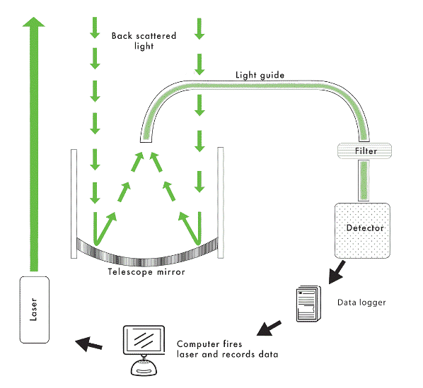
What is Lidar? How Does it Work?
Lidar (LIght Detection And
Ranging), is often refered to as laser radar. Light transmitted by a laser is scattered by atmospheric
consituents and detected by an optical telescope. The properties of the incoming light enable certain properties of the
targets to be determined, and timing of the measurement determines the altitude of the targets.
The NOAA ESRL GMD Lidar Network
The National Oceanic and Atmospheric Administration (NOAA) Earth System Research Laboratory (ESRL), Global Monitoring Laboratory (GMD) operates Lidar at four locations.
- Mauna Loa Observatory, Hawaii (MLO)
- Boulder, Colorado
- Pago Pago, American Samoa (SMO)
- Trinidad Head, California (THD)
At Mauna Loa, Boulder, and Samoa, the Lidars are part of the Network for the Detection of Atmospheric Composition Change (NDACC). At Trinidad Head the Lidar is part of the NASA Micro-pulse lidar network (MPLNET).
What is Camera Lidar? How is it different from Lidar?
CLidar (Camera Lidar), is an innovative on the standard lidar developed at the ESRL Mauna Loa Observatory to measure boundary layer aerosols. Clidar uses a charge-coupled device (CCD) camera to image the entire laser beam from a few hundered meters away.