
2021 Wildfires in Siberia as Seen from the TROPOMI: a "Coal Fire" Hypothesis
L. Yurganov
Joint Center for Earth Systems Technology (JCET), University of Maryland, Baltimore County (UMBC), Baltimore, MD 21250; 803-814-2052, E-mail: yurganov@umbc.edu
Wildfire season of 2021 in the Northern Hemisphere was extremely severe. The Atmospheric Infrared Sounder (AIRS)/Aqua data in accordance with the wildfire data base GFED4 evidences record-breaking CO emissions in the Northern hemisphere and, in particular, in Siberia [1], Fig. 1. These wildfires occurred in permafrost and tundra areas of the Central Siberian plateau. Mechanisms of carbonaceous gas emissions still are unknown. Here we analyze the TROPOspheric Monitoring Instruments (TROPOMI) total column CO measurements for this area and compare them with AIRS data.
The TROPOMI is a Short-Wave Infrared (SWIR) imaging spectrometer on board the European Space Agency’s Sentinel-5 Precursor (S5-P) satellite that was launched into a sun-synchronous polar orbit in October, 2017. The Royal Netherlands Meteorological Institute (KNMI) and the Netherlands Institute for Space Research (SRON) are responsible for the data processing [2]. An excellent spatial resolution (7.2 × 5.6 km² footprint) and high sensitivity to the lowest troposphere allow to resolve small patches of the burning Earth's surface. Single pixels of CO concentrations averaged over the total atmospheric column (XCO ) in early August, 2021 were plotted in a map of Fig. 2. XCO=~500 ppb prevails in the fire zone. Corresponding AIRS data for the same area (not shown here) were in the range 200-250 ppb without any signs of local irregularities. Background XCO for both sounders were well below 100 ppb that was typical for summer time. Relatively small patches with XCO between 650 and 700 ppb were observed. Typical sizes of the "hot spots" varied between single pixels (~6 km) and 5 pixels (~30 km). Some plumes stretched in the direction of the wind for 500 km or more.
The southernmost part of the fire area is characterized by sparse and undersized swampy larch forests. The plateau Putorana with mean height 500-700 m and a maximum of 1,678 m is occupied by mountain tundra or Arctic desert. This area is called the Siberian Traps, it was formed 252 million years ago by one of the largest-known volcanic events of the Earth's geological history. Modern studies assume that the volcanic activity initiated catastrophic combustion of fossil coal. Greenhouse (GH) warming effect of emitted CO2 and CH4 was overlapped by sporadic cooling by volcanic aerosol. Irregular and strong climatic changes led to the fact that ~90% of terrestrial and oceanic species were destroyed (the so-called "Permian extinction"). We hypothesize that coal burning explains anomalous emission of GH gases and CO in July-August, 2021.
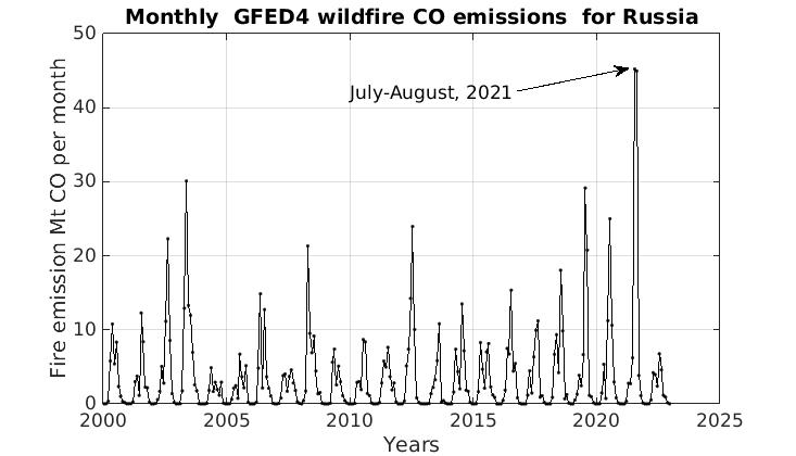
Figure 1. Total monthly CO wildfire emissions from Russia according to the GFED4 database.
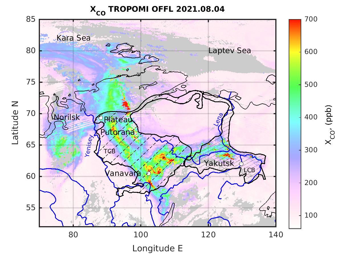
Figure 2. Map of vertically-averaged CO concentration XCO. Hatched areas indicate locations of the world-largest Tunguska Coal Basin (TCB) and Lena Coal Basin (LCB).