Scientific Background
Aerosol measurements began at the GML baseline observatories in the mid-1970's as part of the Geophysical Monitoring for Climate Change (GMCC) program. The original objective of these "baseline" measurements was:
- to detect a response, or lack of response, of atmospheric aerosols to changing conditions on a global scale.
Since the inception of the program, scientific understanding of the behavior of atmospheric aerosols has improved considerably. One lesson learned is that human activities primarily influence aerosols on regional/continental scales rather than global scales. In response to this increased understanding, and to more recent findings that anthropogenic aerosols create a significant perturbation in the Earth's radiative balance on regional scales (Charlson et al., 1992; NRC, 1996; IPCC, 2001), GML expanded its aerosol research program starting in 1992 to include regional aerosol monitoring stations. Currently, through collaborations with both American and international institutions, the NOAA ‘Collaborative Aerosol Network’ includes approximately 25 surface in-situ stations.
The goals of this regional-scale monitoring program are:
- to characterize means, variabilities, and trends of climate-forcing properties of different types of aerosols, and
- to understand the factors that control these properties.
| What do we need to know? | Why? |
|---|---|
| Aerosol Amount | Correlated with forcing |
| Aerosol 'Darkness' | Determines the atmospheric cooling/warming potential of particles |
| Aerosol Size | Related to anthropogenic aerosol contribution Amount of incoming radiation scattered back to space |
| Aerosol Type | Source identification/contribution |
| Location | Aerosol forcing depends on the underlying surface and whether they are above or below clouds. |
GML's measurements also provide ground-truth for satellite measurements and key aerosol parameters for evaluating earth system models.
Data Applications
Climatology and Trends
Long-term measurements are important to capture regionally representative air masses. In contrast, short field campaigns cannot capture climatological variability.

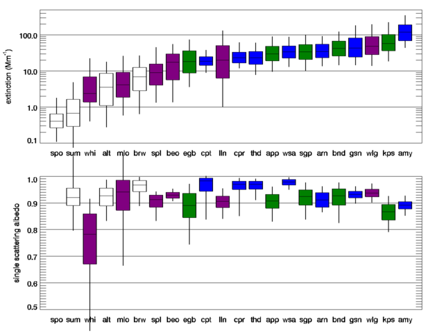
Fig. 1: Example climatologies of aerosol light scattering and single scattering albedo from the NOAA Collaborative Aerosol Network (white = polar sites, purple = high elevation sites, green = continental sites, and blue = coastal sites).
The collaborative in-situ aerosol network captures a wide variety of aerosol types and environments, as demonstrated by the large variation observed in aerosol amount (light extinction, top pane). There is no relationship observed between amount and “nature” of aerosol (single scattering albedo, bottom pane) which further indicates that a variety of air masses with different optical properties are being sampled.
Long-term network observations demonstrate spatial, temporal and compositional differences and can be used to identify trends.

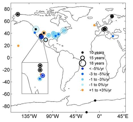
Fig. 2: Long-term trends in aerosol properties
(Figure from
Coen Collaud et al., 2013)
Measurements from the collaborative aerosol network and other long-term observatories have shown that trends in aerosol properties are not spatially homogenous. This is due to complex processes including emissions changes, transport, and transformation of aerosol particles. Trend analysis demonstrates that aerosol optical properties have changed significantly over the last two decades. In the United States, light scattering by aerosol partices is decreasing, possibly due to more effective air pollution control laws. The positive trend observed at Mauna Loa Observatory may be due to increased Asian emissions.
Model Evaluation
Representation of aerosols is a large area of model uncertainty. To address this, confidence in the simulation of current and past trends must be improved. Additionally, processes describing aerosol emissions, sinks and transformation need to be properly parameterized. For example, models must correctly parameterize aerosol microphysics in order to properly simulate cloud formation and, hence, indirect forcing by aerosols.

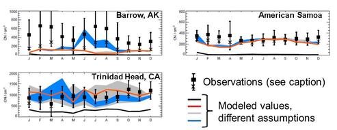
Fig. 3: Evaluation of different microphysical parameterizations using long-term measurements of
aerosol number concentration
(Figure from
Spracklen et al., 2010)
Data from the NOAA/GML aerosol group continue to be used in model evaluation studies. As an example, the work of Spracklen et al. (2010) clearly demonstrated that models must include secondary formation processes (e.g., nucleation) to correctly represent aerosol number concentrations.
Remote Sensing Validation
Remote-sensing retrieval products cannot be considered reliable until they have been independently validated. In-situ aerosol measurements can be related back to physical standards; remotely-sensed aerosol properties cannot be. Long-term aerosol measurements can also be used to assess the scales of spatial/temporal variability to minimize uncertainties in satellite/measurement comparisons.

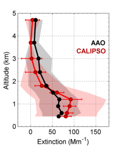
Fig. 4: Mean extinction profiles from airborne in-situ measurements and satellite (CALIPSO)
retrievals; the shaded areas are the standard deviations.
(Figure from
Sheridan et al., 2012).
As an example of remote sensing validation, research comparing in-situ (aircraft) and satellite-retrieved (CALIPSO) extinction showed generally good agreement. However, CALIPSO often overestimated extinction in the boundary layer suggesting, possible issues with CALIPSO’s cloud screening algorithm. These types of statistical data validations offered guidance on CALIPSO’s ability to retrieve aerosol extinction at sites around the globe
Outlook
Data applications as described above indicate the importance of continuing to provide long-term aerosol in-situ measurements for use in analysis of trends and climatologies, evaluation of model simulations of aerosol climatologies and behavior and validation of remote sensing retrievals of aerosol optical properties.
