To understand the global surface energy budget is to understand climate. Because it is impractical to cover the earth with monitoring stations, the answer to global coverage lies in reliable satellite-based estimates. Efforts are underway at NASA and universities to develop algorithms to do this, but such projects are in their infancy. In concert with these ambitious efforts, accurate and precise ground-based measurements in differing climatic regions are essential to refine and verify the satellite-based estimates, as well as to support specialized research.
To fill this niche, the Surface Radiation Budget Network (SURFRAD) was established in 1993 through the support of NOAA's Office of Global Programs. The SURFRAD mission is clear; its primary objective is to support climate research with accurate, continuous, long-term measurements of the surface radiation budget over the United States. This differs from DOE's ARM/SGP site, where surface radiation budget measurements are also being made, in that ARM uses clustered measurements over a limited area for process-oriented studies.
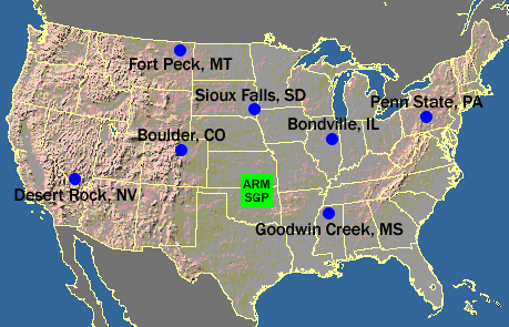
Currently seven SURFRAD stations are operating in climatologically diverse regions: Montana, Colorado, Illinois, Mississippi, Pennsylvania, Nevada and South Dakota. This represents the first time that a full surface radiation budget network has operated across the U. S. Independent measures of upwelling and downwelling, solar and infrared are the primary measurements; ancillary observations include direct and diffuse solar, photosynthetically active radiation, UVB, spectral solar, and meteorological parameters. Data are downloaded, quality controlled, and processed into daily files that are distributed in near real time by anonymous FTP and the WWW (http://gml.noaa.gov/grad/surfrad/). Observations from SURFRAD have been used for evaluating satellite-based estimates of surface radiation, and for validating hydrologic, weather prediction, and climate models. Quality assurance built into the design and operation of the network, and good data quality control ensure that a continuous, high quality product is released.
The SURFRAD program has close ties with scientists at the University of Maryland, the Pennsylvania State University, NESDIS, UCAR's Office of Field Project Support, GCIP, DOE and Unidata. It is also part of the world-wide BSRN network. Operationally, SURFRAD has the cooperation of the USDA, the Fort Peck Tribes, the Pennsylvania State University, and the Illinois State Water Survey.
The stations in Nevada, Pennsylvania and South Dakota are the newest in the network. They were installed in 1998 (Nevada and Pennsylvania) and 2003 (South Dakota). The station in Nevada is collocated with the Desert Rock operational rawinsonde station, which is operated by the Special Operations and Research Division (SORD) of NOAA's ARL. The station in central Pennsylvania is located on Penn State's Agricultural Research Farm about six miles southwest of State College, PA, and is operated by the Meteorology Department. The South Dakota station sits adjacent to the EROS Data Center outside of Sioux Falls. To support satellite and model verification activities, a cloud imaging system, now under commercial development, will be deployed at selected stations. It is also possible that state-of-the-art sensible and latent heat flux measurements will soon become an integral part of SURFRAD, making them complete surface energy budget stations.
The Network
Current SURFRAD stations as well as prospective sites are shown on the map below. The blue dots are established stations and the shaded dots represent desired regions for future sites. The station at Boulder is an operating SURFRAD station and also serves as a calibration facility for network instruments, as well as for spectroradiometers operated by several North American agencies that monitor ultraviolet (UV) radiation.

The site selection process for SURFRAD was a collaborative effort among NOAA, NASA, and university scientists. Locations were chosen with the intent of best representing the diverse climates of the United States. Special consideration was given to places where the landform and vegetation are homogeneous over an extended region so that the point measurements would be qualitatively representative of a large area. The stations at Bondville, Fort Peck, and Goodwin Creek were installed in 1994 within the Mississippi drainage Basin in support of the Global Energy and Water Cycle Experiment's (GEWEX) Continental-Scale International Project (GCIP). Fort Peck and Goodwin Creek are located within well-monitored drainage basins. The station at Boulder was installed in July of 1995, and that at Desert Rock, NV was installed in March 1998.
The station in northwestern Mississippi is located in the Goodwin Creek Experimental Watershed. It is hosted and attended by the USDA/ARS National Sedimentation Laboratory, which is located at the University of Mississippi in Oxford, MS. The Fort Peck station is located on tribal lands of the Fort Peck Tribes, and is attended by their Environmental Office, which has been actively involved in environmental monitoring for more than a decade. Bondville is in a flat agricultural region and is collocated with several other experiments on a site managed by the Illinois State Water Survey. The station at Boulder is attended by the Surface Radiation Research Branch (SRRB) of NOAA's Air Resources Laboratory, which is the managing agency for SURFRAD. The newest station at Desert Rock, NV is the only in the network to be collocated with an operational rawinsonde site.
Instrumentation Strategy
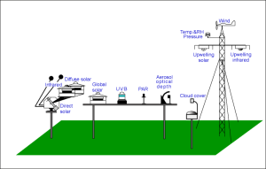
The three platforms on which the instruments and support equipment are mounted are aligned north to south. Upward looking radiometers rest on a long rectangular platform (~0.3 m by 3 m) that is made of an off-white fiberglass grating. It is elevated about 1.5 to 2 m off of the ground by two steel posts that are set in concrete (below the frost line). The data logging, power distribution, and communication equipment are fastened to these posts. A smaller platform about 3-4 m south of the main platform supports an automatic sun tracker that holds the pyrheliometer, shaded pyrgeometer and shaded pyranometer. About 15 m north of the main platform is a 10-m tower with downward looking radiometers and meteorological instruments. A crossarm supporting the downward looking radiometers is also aligned north to south. This station layout ensures that the tower, and the instruments mounted on it, will never shade the upward looking radiometers on the main platform. Electrical power for the station is conditioned by a 1.15 KVA uninterruptable power supply that has the capability to supply power through battery backup for a short period (~2 hours) if the line power fails.
Radiation measurements at SURFRAD stations cover the range of the electro- magnetic spectrum that affects the earth/atmosphere system. Global solar and its components are measured separately. Total downwelling (global) solar radiation is measured on the main platform by an upward looking broadband pyranometer. The direct component is monitored with a normal incidence pyrheliometer (or NIP) mounted on an automatic sun tracker, and the diffuse component is measured by a shaded pyranometer. Diffuse solar was not in the original suite of SURFRAD measurements. The shaded pyranometer was added in 1996 when a support platform with a shade arm mechanism was fitted to the trackers. A third pyranometer is mounted facing downward on a crossarm near the top of the 10-meter tower to measure solar radiation reflected from the surface. An upward looking pyrgeometer on the main platform measures long wave (thermal infrared) radiation emitted downward by clouds and other atmospheric constituents. Another pyrgeometer, mounted facing downward on the crossarm atop the tower, senses upwelling long wave radiation. These measurements of upwelling and downwelling in the solar and infrared wavebands constitute the complete surface radiation budget.
Besides the surface radiation budget, other ancillary parameters are monitored. There are two instruments on the main platform that monitor wavebands of special interest. A UVB radiometer measures the degree of harmful ultraviolet radiation (290-320 nm) that evades the ozone layer and reaches the surface. Another instrument monitors the intensity of the waveband active in photosynthesis (400 to 700 nm). The final radiometer in the SURFRAD suite is the Multi-Filter Rotating Shadowband Radiometer (MFRSR) which measures both global and diffuse solar radiation in one broadband and six narrow bands of the solar spectrum. These are useful for obtaining aerosol loading information. Instruments for measuring wind speed and direction, air temperature, and relative humidity also reside at the top of the 10-meter tower. A barometer in the data logger box measures station pressure.
The redundancy of three component solar measurements (global, direct and diffuse) provides a useful tool for quality control of the SURFRAD data. In addition, the sum of the diffuse and direct is actually a better measure of total solar than the global measurement alone because when the sun is near the horizon, a change in the cosine response of the global pyranometer's sensor introduces errors in the global measurement.
Total sky imagers, ceilometers, down-pointing MFR spectral instruments (for spectral albedo), and Purple Air aerosol monitors have been added to all SURFRAD stations since their initial deployments.
Calibrations
SURFRAD has adopted the standards for measurement set by the Baseline Surface Radiation Network (BSRN) which is sponsored by the World Climate Research Program (WCRP) of the World Meteorological Organization (WMO). Accuracies achievable for shortwave measurements are ~2% for pyrheliometers and ~5% for pyranometers--or 15 Watts/m2, whichever is the largest. The best accuracy that is achievable for pyrgeometers is now at ~5 Watts/m2, which is a combination of the accuracy of the world standard and the uncertainty of the transfer. These uncertainties are only valid if the radiometers are calibrated and operated according to BSRN specifications. To achieve these uncertainty goals in monitoring radiometers, the broadband solar instruments are calibrated NOAA in Boulder, Colorado using a cavity radiometer that is directly traceable to the World Radiometric Reference (WRR) at the World Radiation Center in Davos, Switzerland. Likewise, SURFRAD pyrgeometers are calibrated against three standard pyrgeometers whose calibrations are directly traceable to the World Infrared Standard Group (WISG) in Davos, Switzerland. At our test facility at Table Mountain near Boulder, Colorado, SURFRAD maintains three reference instruments of each type that the its instruments are checked against before and after deployment.
The wind monitor which measures speed and direction is calibrated is a wind-tunnel at the Atmospheric Turbulence and Diffusion Division (ATDD) of ARL in Oak Ridge, Tennessee. It is replaced annually with a new or refurbished, recalibrated instrument. A chip that is the primary sensing component of the relative humidity probe is also replaced on an annual basis. The temperature and humidity probe may be soon replaced with a more robust sensor that should last longer than those presently deployed.

